Bathurst Flood Study Update
Share Bathurst Flood Study Update on Facebook Share Bathurst Flood Study Update on X (formerly Twitter) Share Bathurst Flood Study Update on Linkedin Email Bathurst Flood Study Update link

Council, with the support of the NSW Government, is currently undertaking a Flood Study Update for the Macquarie Wambuul River floodplain in the Bathurst area. The study is being completed by Stantec Australia with the study area including:

  • approximately 29km of the Macquarie Wambuul River, from the confluence of the Fish and Campbells River to the boundary between the localities of Dunkeld and Rock Forest; and
  • the local tributaries of Jordan Creek, Raglan Creek, Saltram Creek, Hawthornden Creek, Kellosheil Creek, Sawpit Creek and other key urban waterways and drainage lines.

The draft Flood Study Update has now been completed and is on public exhibition. A copy of the draft Flood Study Update is available in the Document Library.

To gain a better understanding of what this means there is a range of other information also provided in the Document Library including:

  • Explanation document which outlines the aims and objectives of the Bathurst Flood Study Update as well as progress on the project to date
  • Frequently Asked Questions including a glossary of key phrases and flood terminology
  • A video presentation providing an explanation of the draft Flood Study Update.
  • Maps showing the flooding extent and Flood Planning Area
  • Links to Council's flood related documents and policies
  • Links to key flood documentation and guides

A question-and-answer tool has also been created below where you can ask questions which are general in nature and answers will be provided.

The News Feed below also includes information about Flood Risk Management and the Flood Study area.

How can you be involved?

Council invites written submissions in relation to the draft Bathurst flood study update. Any submission needs to be lodged with Council by 4pm on Friday 28 August 2026 and must include your name and address. Any submission that you make may be included without alteration (including names and addresses) in reports that are available to the public in Council business papers. Council will consider all submissions made to it, but to influence the Council’s decision any submission you make must be relevant and well founded. Written submissions can be lodged through Council’s Yoursay page.

If you have specific questions or concerns which are not addressed via the Yoursay page including the question forum, you are encouraged to attend one of the one-on-one information sessions to discuss the report. These sessions will be hosted by Council’s Engineering and Planning Departments along with a representative from Stantec Australia. Council’s technical consultant, Stantec, have provided a pre-recorded presentation on the flood study’s project background and the progress to-date, including key project outcomes. Residents are strongly encouraged to watch the video presentation prior to requesting RSVP for one-on-one sessions.

One-on-one sessions will be made available on the following dates:


Session OneSession Two
DateTuesday 4 August 2026Tuesday 4 August 2026
Time2pm - 5pm6pm - 9pm
VenueBathurst Memorial Entertainment CentreBathurst Memorial Entertainment Centre

Session ThreeSession Four
DateWednesday 5 August 2026Wednesday 5 August 2026
Time9am - 12 midday1pm - 4pm
VenueBathurst Memorial Entertainment CentreBathurst Memorial Entertainment Centre
RSVPs to attend are essential and should be made to Council’s Engineering Department on 6333 6100.
Pease note:
  • We will need to collect some key data from yourself as part of the booking process
  • RSVPs must be received by 4pm Monday 3 August 2026.

These sessions have an allocated time of 15 minutes. Residents are encouraged to watch the video presentation by Stantec on the draft report prior to their meeting with Council. Please ensure you are on time for your allocated booking. If you are late, it may not be possible to extend your booking.

FIND OUT MORE

To find out more about this project and links to Council’s existing floodplain management plans and studies please see the Document Library and the News Feed below. Importantly the Explanation Document provided outlines in detail the aims and objectives of the Bathurst Flood Study Update project.


REGISTER TO FOLLOW THIS PROJECT

To stay informed as this project progresses through the Flood Risk Management Process, as outlined in the Explanation Document, please register your email address via the Register to get involved button.

We will keep you updated on YourSay Bathurst.


GENERAL ENQUIRIES

The community are encouraged to contact Council’s Engineering Department on 6333 6100 or email council@bathurst.nsw.gov.au should you have any concerns or would like further detailed information.


MAKE A SUBMISSION

You can make a submission via the Submission form below, or send in your submission to council@bathurst.nsw.gov.au or to The General Manager PMB17 Bathurst NSW 2795. Submissions must be received by 4pm Friday 28 August, 2026.


Council, with the support of the NSW Government, is currently undertaking a Flood Study Update for the Macquarie Wambuul River floodplain in the Bathurst area. The study is being completed by Stantec Australia with the study area including:

  • approximately 29km of the Macquarie Wambuul River, from the confluence of the Fish and Campbells River to the boundary between the localities of Dunkeld and Rock Forest; and
  • the local tributaries of Jordan Creek, Raglan Creek, Saltram Creek, Hawthornden Creek, Kellosheil Creek, Sawpit Creek and other key urban waterways and drainage lines.

The draft Flood Study Update has now been completed and is on public exhibition. A copy of the draft Flood Study Update is available in the Document Library.

To gain a better understanding of what this means there is a range of other information also provided in the Document Library including:

  • Explanation document which outlines the aims and objectives of the Bathurst Flood Study Update as well as progress on the project to date
  • Frequently Asked Questions including a glossary of key phrases and flood terminology
  • A video presentation providing an explanation of the draft Flood Study Update.
  • Maps showing the flooding extent and Flood Planning Area
  • Links to Council's flood related documents and policies
  • Links to key flood documentation and guides

A question-and-answer tool has also been created below where you can ask questions which are general in nature and answers will be provided.

The News Feed below also includes information about Flood Risk Management and the Flood Study area.

How can you be involved?

Council invites written submissions in relation to the draft Bathurst flood study update. Any submission needs to be lodged with Council by 4pm on Friday 28 August 2026 and must include your name and address. Any submission that you make may be included without alteration (including names and addresses) in reports that are available to the public in Council business papers. Council will consider all submissions made to it, but to influence the Council’s decision any submission you make must be relevant and well founded. Written submissions can be lodged through Council’s Yoursay page.

If you have specific questions or concerns which are not addressed via the Yoursay page including the question forum, you are encouraged to attend one of the one-on-one information sessions to discuss the report. These sessions will be hosted by Council’s Engineering and Planning Departments along with a representative from Stantec Australia. Council’s technical consultant, Stantec, have provided a pre-recorded presentation on the flood study’s project background and the progress to-date, including key project outcomes. Residents are strongly encouraged to watch the video presentation prior to requesting RSVP for one-on-one sessions.

One-on-one sessions will be made available on the following dates:


Session OneSession Two
DateTuesday 4 August 2026Tuesday 4 August 2026
Time2pm - 5pm6pm - 9pm
VenueBathurst Memorial Entertainment CentreBathurst Memorial Entertainment Centre

Session ThreeSession Four
DateWednesday 5 August 2026Wednesday 5 August 2026
Time9am - 12 midday1pm - 4pm
VenueBathurst Memorial Entertainment CentreBathurst Memorial Entertainment Centre
RSVPs to attend are essential and should be made to Council’s Engineering Department on 6333 6100.
Pease note:
  • We will need to collect some key data from yourself as part of the booking process
  • RSVPs must be received by 4pm Monday 3 August 2026.

These sessions have an allocated time of 15 minutes. Residents are encouraged to watch the video presentation by Stantec on the draft report prior to their meeting with Council. Please ensure you are on time for your allocated booking. If you are late, it may not be possible to extend your booking.

FIND OUT MORE

To find out more about this project and links to Council’s existing floodplain management plans and studies please see the Document Library and the News Feed below. Importantly the Explanation Document provided outlines in detail the aims and objectives of the Bathurst Flood Study Update project.


REGISTER TO FOLLOW THIS PROJECT

To stay informed as this project progresses through the Flood Risk Management Process, as outlined in the Explanation Document, please register your email address via the Register to get involved button.

We will keep you updated on YourSay Bathurst.


GENERAL ENQUIRIES

The community are encouraged to contact Council’s Engineering Department on 6333 6100 or email council@bathurst.nsw.gov.au should you have any concerns or would like further detailed information.


MAKE A SUBMISSION

You can make a submission via the Submission form below, or send in your submission to council@bathurst.nsw.gov.au or to The General Manager PMB17 Bathurst NSW 2795. Submissions must be received by 4pm Friday 28 August, 2026.


  • Flood risk management process

    Share Flood risk management process on Facebook Share Flood risk management process on X (formerly Twitter) Share Flood risk management process on Linkedin Email Flood risk management process link

    Council is primarily responsible for Flood Risk Management (FRM) within the Bathurst Regional Local Government Area under the NSW Government’s Flood Prone Land Policy:

    https://www.environment.nsw.gov.au/topics/water/floodplains

    Council is responsible for formulating and implementing Flood Risk Management Plans in accordance with this Policy.

    The aim of Flood Risk Management is to manage the impact of flooding and flood liability on owners and occupiers of flood-prone property and reduce public and private losses resulting from flooding.

    Bathurst Regional Council is committed to comprehensive Flood Risk Management. The last major study for the Macquarie Wambuul River in Bathurst was the 1995 Bathurst Floodplain Management Plan. An updated Flood Study will incorporate advancements in flood modelling techniques, updates to the flood risk management process and review Council’s existing flood mitigation infrastructure.

    Council has received financial support under the NSW Floodplain Management Program to undertake a flood study for Bathurst. Council has engaged specialist consultants, Stantec, to prepare the Bathurst Flood Study Update, representing stage 1 of the Flood Risk Management process.

    Stage

    What does it do

    Status

    Stage 1:

    Flood Study Update

    Determines the nature and extent of flooding.

    Stage 1a Consultation: Council is seeking community input in the data collection process to inform the Bathurst Flood Study Update - COMPLETED

    Stage 1b Consultation: Public Exhibition of draft Flood Study Update – NOW UNDERWAY

    Stage 2:

    Flood Risk Management Plan Update

    Evaluates management options for the floodplain in respect of both existing and proposed development.

    Future Stage

    Stage 3:

    Finalisation of the Flood Risk Management Plan Update

    Involves formal adoption by Council of an updated plan of management for the floodplain.

    Future Stage

    Stage 4:

    Implementation of the Updated Plan

    Flood mitigation works to protect existing development. Use of planning controls under Council’s Local Environmental Plan and Development Control Plan to ensure new development is compatible with the flood hazard. Improvements to flood emergency management procedures.

    Future Stage

    Council is primarily responsible for Flood Risk Management (FRM) within the Bathurst Regional Local Government Area under the NSW Government’s Flood Prone Land Policy:

    https://www.environment.nsw.gov.au/topics/water/floodplains

    Council is responsible for formulating and implementing Flood Risk Management Plans in accordance with this Policy.

    The aim of Flood Risk Management is to manage the impact of flooding and flood liability on owners and occupiers of flood-prone property and reduce public and private losses resulting from flooding.

    Bathurst Regional Council is committed to comprehensive Flood Risk Management. The last major study for the Macquarie Wambuul River in Bathurst was the 1995 Bathurst Floodplain Management Plan. An updated Flood Study will incorporate advancements in flood modelling techniques, updates to the flood risk management process and review Council’s existing flood mitigation infrastructure.

    Council has received financial support under the NSW Floodplain Management Program to undertake a flood study for Bathurst. Council has engaged specialist consultants, Stantec, to prepare the Bathurst Flood Study Update, representing stage 1 of the Flood Risk Management process.

    Stage

    What does it do

    Status

    Stage 1:

    Flood Study Update

    Determines the nature and extent of flooding.

    Stage 1a Consultation: Council is seeking community input in the data collection process to inform the Bathurst Flood Study Update - COMPLETED

    Stage 1b Consultation: Public Exhibition of draft Flood Study Update – NOW UNDERWAY

    Stage 2:

    Flood Risk Management Plan Update

    Evaluates management options for the floodplain in respect of both existing and proposed development.

    Future Stage

    Stage 3:

    Finalisation of the Flood Risk Management Plan Update

    Involves formal adoption by Council of an updated plan of management for the floodplain.

    Future Stage

    Stage 4:

    Implementation of the Updated Plan

    Flood mitigation works to protect existing development. Use of planning controls under Council’s Local Environmental Plan and Development Control Plan to ensure new development is compatible with the flood hazard. Improvements to flood emergency management procedures.

    Future Stage

  • Bathurst Flood Study update - Study area

    Share Bathurst Flood Study update - Study area on Facebook Share Bathurst Flood Study update - Study area on X (formerly Twitter) Share Bathurst Flood Study update - Study area on Linkedin Email Bathurst Flood Study update - Study area link

    The City of Bathurst is subject to mainstream flooding from the Macquarie Wambuul River and its tributaries.

    The Bathurst Flood Study Update will consider:

    • approximately 29 km of the Macquarie Wambuul River, from the confluence between Fish and Campbells Rivers to the boundary between the localities of Dunkeld and Rock Forest; and
    • the local tributaries of Jordan Creek, Raglan Creek, Saltram Creek, Hawthornden Creek, Sawpit Creek and Queen Charlottes Vale Creek.

    An indicative map of the Study area is provided in Figure 1.
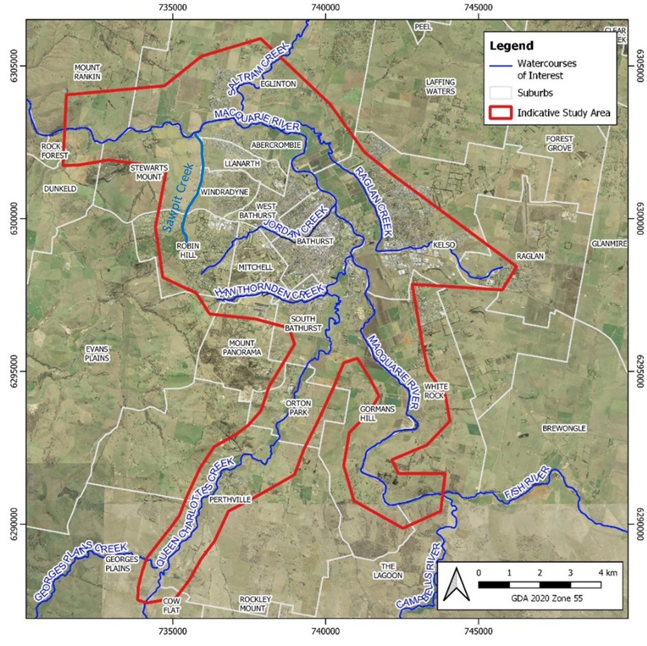
    Figure 1: Study Area for the Bathurst Flood Study Update


    The City of Bathurst is subject to mainstream flooding from the Macquarie Wambuul River and its tributaries.

    The Bathurst Flood Study Update will consider:

    • approximately 29 km of the Macquarie Wambuul River, from the confluence between Fish and Campbells Rivers to the boundary between the localities of Dunkeld and Rock Forest; and
    • the local tributaries of Jordan Creek, Raglan Creek, Saltram Creek, Hawthornden Creek, Sawpit Creek and Queen Charlottes Vale Creek.

    An indicative map of the Study area is provided in Figure 1.

    Figure 1: Study Area for the Bathurst Flood Study Update


  • Stage 1a consultation

    Share Stage 1a consultation on Facebook Share Stage 1a consultation on X (formerly Twitter) Share Stage 1a consultation on Linkedin Email Stage 1a consultation link

    STAGE 1A CONSULTATION HAS BEEN COMPLETED

    HOW CAN YOU BE INVOLVED IN STAGE 1?

    To inform stage one, Council is seeking the views and experiences of the Bathurst community in relation to flooding and past storm events.

    Council will be holding information sessions to inform the community about the Flood Risk Management process as follows:


    Session One

    Session Two

    Date

    Monday 29 July 2024

    Monday 29 July 2024

    Time

    2pm

    6pm

    Venue

    Bathurst Memorial Entertainment Centre

    Bathurst Memorial Entertainment Centre

    RSVPs to attend are essential and should be made to Council’s Engineering Department on 6333 6100 or email Sue.Miller@bathurst.nsw.gov.au by

    STAGE 1A CONSULTATION HAS BEEN COMPLETED

    HOW CAN YOU BE INVOLVED IN STAGE 1?

    To inform stage one, Council is seeking the views and experiences of the Bathurst community in relation to flooding and past storm events.

    Council will be holding information sessions to inform the community about the Flood Risk Management process as follows:


    Session One

    Session Two

    Date

    Monday 29 July 2024

    Monday 29 July 2024

    Time

    2pm

    6pm

    Venue

    Bathurst Memorial Entertainment Centre

    Bathurst Memorial Entertainment Centre

    RSVPs to attend are essential and should be made to Council’s Engineering Department on 6333 6100 or email Sue.Miller@bathurst.nsw.gov.au by 3:00pm on Thursday 25 July 2024.


    Council invites the Bathurst Community, particularly those located in or close to the Study Area, to complete the Bathurst Flood Study Update Questionnaire (available below) to share your experiences and views about flooding and past storm events.

    Hard copy questionnaire forms are also available from Council’s Engineering Department.

    You are also encouraged to share photos or links to videos of past storm events in the Bathurst region. Photos and videos can be shared with Council through any of the following means:

    • Upload photographs or links to videos via the online Questionnaire (available below). Up to five (5) individual photographs can be uploaded below OR you can combine photographs into one Microsoft Word document and upload the file below.
    • Email photos and videos directly to Council. Please email to council@bathurst.nsw.gov.au with your relevant contact details and property information.
    • Post hardcopies of the photographs to Council. Please enclose your relevant contact details and property information and post any hardcopies to: Private Mail Bag 17, Bathurst NSW 2795.
    • Submit hardcopies of the photographs to Council in person. Please submit any hardcopies to Council's Engineering Services desk on the Second Floor of the Civic Centre (158 Russell Street Bathurst NSW 2795).
    • Submit electronic copies of the photographs and videos to Council (using a USB stick or CD) in person. Please submit any electronic copies to Council's Engineering Services desk on the Second Floor of the Civic Centre (158 Russell Street Bathurst NSW 2795).
    • Contact Council's Engineering Department for any further assistance on 6333 6100.

    Completed questionnaires/shared imagery must be submitted by Friday 16 August 2024.

    RESIDENT/LANDOWNER SURVEY 2024

    This survey will help us to determine the flooding issues that are important to you within the Study area. The information you provide will helps us:

    • better understand the flooding problem in the local tributaries
    • inform planning and development decisions in areas affected by flooding
    • prepare for an informed Flood Risk Management Plan in the future

    This survey has been provided using an indicative area near current flood extent, and receiving this survey does not carry implication that your property is, or will be, flood impacted.

    WHY IS YOUR INPUT IMPORTANT?

    Council’s consultants will use the photo and video evidence and stories collected from this first stage of community engagement to test the updated flood model and verify its accuracy.

Page last updated: 21 Jul 2026, 02:57 PM