FAQs
What prompted an update to the existing flood study and model?
Council is responsible for managing flood risk within its Local Government Area in accordance with the NSW Flood Risk Management Framework. This responsibility includes understanding flood behaviour and risk, planning for current and future flood hazards, considering flood risk in strategic planning and development decisions.
The completion of the Perthville levee in 2022, signified the completion of the flood mitigation infrastructure identified in the 1995 Management Plan.
With those works completed an updated flood study would allow Council to take advantage of significant technological advancement in modelling techniques and computing power along with updated guidance on flood modelling practises while meeting its flood risk management obligations. An updated flood study would also provide modelling for tributaries that were not original included in the 1993 flood study.
How does this flood study help Council in floodplain management?
The Flood Study is a critical part of the NSW Government's Flood Risk Management Framework and is the essential first step before a Flood Risk Management Plan can be prepared. It provides Council with the best available technical understanding of how flooding behaves across the floodplain and the likelihood of flooding occurring during different flood events.
The Flood Study Update provides updated flood information by incorporating improved survey data, advances in flood modelling technology, updated rainfall and flood information, and changes to the floodplain that have occurred over time. As a result, it provides a more accurate and contemporary assessment of flood behaviour and flood risk.
The outcomes of the Flood Study support many of Council's day-to-day responsibilities. They provide the technical basis for land use planning and development assessment, emergency management planning, infrastructure design, community education, and identifying areas where people, property and infrastructure are exposed to flood risk. The study also identifies flood extents, depths, velocities and hazard classifications that inform planning decisions and help ensure future development is compatible with flood risk.
Under the NSW Flood Risk Management Framework, the completed Flood Study forms the foundation for the next stage—a Flood Risk Management Study and Plan—which evaluates a range of flood mitigation and risk management options. These may include structural measures, such as levees, as well as non-structural measures, including planning controls, emergency response improvements, community awareness initiatives and property-level resilience measures. Having an up-to-date Flood Study also strengthens Council's ability to seek grant funding for future flood mitigation projects by providing the evidence base needed to assess and prioritise potential mitigation options.
More information about the NSW Flood Risk Management Framework is available on the NSW Department of Climate Change, Energy, the Environment and Water (DCCEEW) website, and in the Draft Flood Study report currently on public exhibition.
What type of flooding affects the Bathurst Region?
The Bathurst Region has been affected by both riverine flooding from the Queen Charlottes Vale Creek (QVC), the Macquarie Wambuul River, and overland flooding from local tributaries.
Has the impact of climate change been considered?
The Flood Study Update has used the latest guidance from Australian Rainfall and Runoff regarding climate change modelling for flooding. The report has considered 1% AEP current (2030) and future (2100) scenarios under Shared Socioeconomic Pathway 2-4.5 (SSP2-4.5). A detailed explanation has been provided in Section 7.4.5 and Section 9.6 of the Draft Flood Study Update report.
Will the draft flood planning area affect me?
If you have been identified in the draft flood planning area, this means you may be subjected to flood planning controls under the Bathurst Development Control Plan (DCP) & Local Environment Plan (LEP) once the content of the flood study is adopted. Note, flood related planning controls only apply to work requiring development consent through the NSW Planning Portal.
There will be no changes to flood-related policies until after the adoption of the draft Flood Study report. After which, Council’s Planning Department will start the process to review its flood related policies, taking into consideration the report’s findings.
What is the current flood planning policy?
Bathurst Region’s current planning conditions require constructions within the flood planning area to have a finished floor level 500mm above the 1%AEP flood level. This 500mm freeboard requirement has been included in the extent of the flood planning area. In addition, any activity below the flood level, including earthworks necessary to satisfy the freeboard requirement, will be required to undertake flood impact assessment. If the assessment concludes a significant impact upon the performance of the floodplain, the proposal will need to be modified to reduce its impact.
The flood extent shown in the flood planning area doesn’t look right?
Flood planning area (FPA) mapping is intended as a tool during the development control process. The difference between FPA mapping and flood inundation mapping is the FPA’s inclusion of the freeboard requirement by adding 500mm to the flood height from the 1%AEP event result. This inclusion is intended to assist the consent authority to identify properties impacted by flooding. This method works best for most of the properties near the Macquarie River floodplain, but less so for properties adjacent to a major stormwater drainage infrastructure. This is primarily due to the limitation on the process of capturing LiDAR terrain through urban areas. An explanation on the LiDAR data can be found below, provided by US Geological Survey Agency:
What is Lidar data and where can I download it?
If you observed your property as not affected amid major flooding events e.g. November 2022, but the FPA mapping suggests otherwise, this could mean its ground level is within the 500mm freeboard. If your property has been flooded but the FPA mapping does not show this, this may because this flood study does not capture overland flow, except stormwater surcharge from major drainage infrastructure.
Part of the public exhibition process is for Council to seek feedback, if you believe the extent of flooding is incorrect Council will consider individual submissions.
Will this affect my insurance?
When the final flood study report is adopted, contents of the Flood Study Update will be made available through the Australian Flood Risk Information Portal. Bathurst Regional Council is under an obligation to provide up-to-date flooding information to inform engineers, insurers, emergency services and the public about the flooding risk in the Bathurst Region.
Council cannot determine how insurers calculate premiums or whether an individual property's insurance costs will change.
Insurance companies use a range of information when assessing flood risk, which may include their own flood models, historical claims data, property characteristics and publicly available flood information, including council flood studies.
An updated Flood Study does not automatically result in higher insurance premiums. In some cases, improved flood modelling may identify a lower level of flood risk than previously understood, while in other cases it may identify a higher level of risk. The outcome will depend on the individual property and the insurer's assessment methods.
Residents are encouraged to contact their current insurance provider to discuss the implications of the content of the Draft Flood Study report.
More information on flood insurance can be found on the Insurance Council of Australia website. Flood insurance explained - Insurance Council of Australia
Will this effect my property value?
There is no simple answer to this, as property values are influenced by many factors, including location, housing demand, property condition, local amenities and market conditions.
Flood risk information has long been considered by purchasers, lenders and insurers when making decisions. An updated Flood Study ensures these decisions are based on the best available information. It also helps Council make informed planning decisions, improve emergency management and identify opportunities for future flood mitigation that may reduce flood risk over time.
Glossaries and flood terminology
Important Glossaries:
• Tributary is a stream that flows into a larger stream. In the context of the report, it refers to smaller bodies of water such as Jordan Creek, Hawthornden Creek, Raglan Creek etc. Full list of tributaries within the scope of the flood study is detailed in the report.
• Mainstream refers to the greater Macquarie River floodplain.
• 1% AEP (annual exceedance probability), colloquially known as the 1-in-100-year event, represents a flood or rainfall event that has a 1% (1 in 100) chance of being reached or exceeded in any given year.
• 1%AEP Current Day event, otherwise abbreviated as 1%AEP 2030 SSP2, is the consideration given due to impact of climate change upon the intensity of rainfall up to year 2030 under Shared Socioeconomic Pathways 2-4.5 (SSP2-4.5)
• 1%AEP Future Day event, otherwise abbreviated as 1%AEP 2100 SSP2, is the consideration given due to impact of climate change upon the intensity of rainfall up to year 2100 under Shared Socioeconomic Pathways 2-4.5 (SSP2-4.5)
• Probable maximum flood (PMF) is the flooding situation derived from the probable maximum precipitation (PMP), which is the theoretical maximum precipitation for a catchment. PMP and PMF intends to identify the maximum flooding possible to inform the planning and development of critical infrastructure such as hospitals.
• Flood prone land refers to land susceptible to flood by the PMF event.
• Flood inundation area refers to land susceptible to flood by the 1% AEP event.
• Flood planning area (FPA) is the mapping extent derived from the flood inundation mapping area plus 500mm freeboard above the 1% AEP flood level.
• Flood planning level is given as the minimum floor level above the 1% AEP flood level. This includes 500mm of freeboard.
• Freeboard is a safety margin added to a designated flood level, typically 500mm to provide addition protection to a structure or building.
• SSPs, or Shared Socioeconomic Pathways, are climate change scenarios of projected socioeconomic global changes, for up to year 2100. There have been five scenarios established, per figure 1, where SSP2 is the “optimistic middle-of-the-road scenario”.
A detailed explanation for SSP and climate change can be found below:
The Shared Socio‐Economic Pathways (SSPs): An Overview
https://unfccc.int/sites/default/files/part1_iiasa_rogelj_ssp_poster.pdf
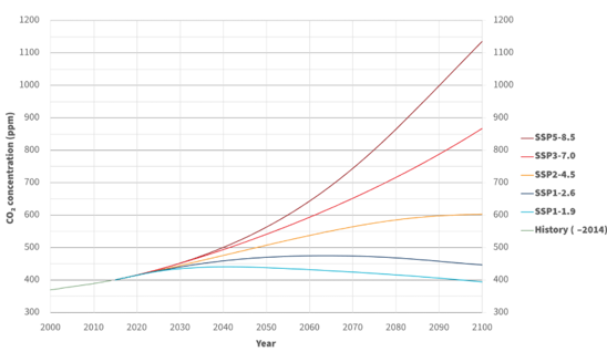 Figure 1 Predicted atmospheric CO₂ concentrations for different shared socioeconomic pathways (SSPs) across the 21st century (projected by MAGICC7